|
|
| http://images.google.com/images?um=1&hl=en&q=storms |
There are three different names of tropical cyclones around the world. There are hurricanes, typhoons, and cyclones.
There are also some main ingredients for these tropical storms just like thunderstorms. They need warm waters about
150 ft deep, which is the most important key ingredient, a cool moist atmosphere, a minimum distance of 300 miles from the
equator, a surface disturbance, and low values of vertical winds.
Some of these disturbances may include: Easterly Waves, West Africa Disturbance Line (WADL), Tropical Upper Troposphere
Trough (TUTT), or Old Frontal Boundary.
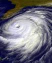
STRUCTURE
The eye is the center of the hurricane. This is generally very calm with winds of 15 mph and 20-40 miles across.
The wider the eye is the less intense the hurricane is and vice versa. A lot of times birds get caught in the eye from
sea. They just circle the eye till it's over and they can land somewhere.
The eyewall contains a large ring of strong thunderstorms. The eye or eyewall can change and with it comes
changes in wind speed which indicates the storm's intensity.
Rainbands are bands of thunderstorms that extend out from the center of the hurricane in a spiral form. These thunderstorms
are just like the ones seen on land. They can produce very heavy rain and tornadoes; however, there are usually gaps
in the rainbands where there may be no rainfall at all.
NAMES
Naming tropical storms and cyclones is actually very easy. There is a list for all the oceans and seas that have
these storms and there names that they are ready to use. When there is a storm they pick out the next name and they
just continue down the list.
|