|
|
 |
|
|
| http://images.google.com/images?hl=en&q=tornadoes&um=1&ie=UTF-8&sa=N&tab=wi |
|
|
|
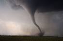
April through June is known as Tornado Season. The most occur in the midwest and has been nicknamed
"tornado alley." When a tornado is viewed on radar it has a hook shape. When the tornado starts to descend, it
is viewable because of the water droplets inside of it. The color of a cloud. The full diameter of the tornado
is not always viewable, only where all the debrees and water droplets are.
"The exact processes for the formation of a funnel are not known yet. Recent theories suggest that
once a mesocyclone is underway, tornado development is related to the temperature differences across the edge of downdraft
air wrapping around the mesocyclone."
|
|
|
TORNADO WATCH - This means there is a possibility of rotating wind and tornadoes
TORNADO WARNING - This means the NWS has detected a tornado by the doppler radar or a tornado has been spotted
on the ground.
ENHANCED FUJITA SCALE
 |
|
|
|
|
|
|
|
|
|
|
|
|
|
|
|
|
|
|
|
|
|
|
|
|
|
|
|
EF4
|
violent
|
166-200
|
Devastating
|
|
EF5
|
violent
|
>200
|
Incredible
|
|
|
|
|
| http://images.google.com/images?hl=en&q=waterspouts&um=1&ie=UTF-8&sa=N&tab=wi |
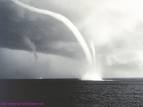
WATERSPOUTS
You also may have heard of waterspouts. These are tornadoes that form over water, mostly on the coast
of the Gulf of Mexico. They are usually weak. These may eventually come on land a cause some major damage.
|
|
|
|
|
|
|
|
|
|
|
|